Saint Leu 1400
Arrondissement of Saint-Paul, Reunion
Sign In to get the latest weather!
It's free to join spedmo and start collaborating
Current Conditions
No Alerts.
Remember before every flight, check your equipment, reassess the conditions and ask yourself if 'I'm safe'?

Required Launch Wind Direction
Take Off
-21.1509, 55.3427 : 1390.0 m
Sunrise
6:43 AM
Sunset
5:47 PM
Time Zone
Réunion Time (+0400)
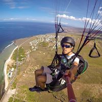
use this site very early, before cloud comming. Flight plan : Flight starts over La Chaloupe village, then, either leave straight on towards the sea, or hang up the 800 site by flying along the relief. Numerous cross possibilities.
alti: 1370m Situation : West coast - St LEU bay GPS : WGS84 S -21.15094 - E 55.34269 Altitude : 1 400 m ASL Access : This site is situated above La Chaloupe village. Take the road to Colimaçons and keep going towards La Chaloupe. Once at the village, take Vaudeville road on the left. The site is about 4 km, on the right just by the road, look for a small wind sock. If you reach a concrete road, it means you went past the 1400, but you are now heading towards for the 1500... alti: 0m on the beach, near the 'ferme corail'. same than 'colimaçon' site. na. na.
Aerology : The cloud cover may be very fast with ceiling between 900m and 1200m : Take off early, before any clouds form to avoid any surprise. The risks are the same as for Colimaçon site : everything is quiet on the takeoff, but there can be a lot wind on the beach. Please, always watch carefully the sea before taking off to make sure there is no strong wind at touch down. A look at the weather report, internet or other, is an additional safety measure...