For Flight - History and Evolution
April 2, 2020
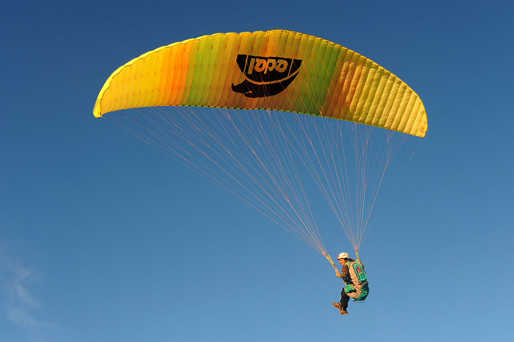 There was a time when free flight was really free. Free not only because we do not use unnatural means to keep us in the sky, free also because it was a sport whose main achievement was simple to take your feet off the ground and glide through the air ... free, even for a determined time, from absolute and unrestricted limitation of the law of gravity. Free because there is no greater or lesser achievement, just as in nature, where a migratory bird or that flies very high never looks down or diminishes a bird that only flies low or does not expand its horizons. The flight was free and so were we, but limited. That the human being does not accept!
 Well, as soon as the sport started to be seen in a more technical and objective way, the practitioners allowed themselves and explored the limits. Paragliding was born as a tool for descending a mountain and man, in his relentless impetus for evolution, soon transformed it into a tool for crossing mountains. And, precisely in the midst of this evolution, electronics appeared as a tool, albeit artificial, to help us feel and read the atmosphere around us better, with this more accurate information from a medium that was not ours so natural, we can make better use of the entire flight moment and delay the inevitable landing for longer and longer.
 In the beginning, basically, equipment was developed to read the pressure changes and, in this way, emit a sound signal warning that the pilot was in an upward movement. Soon after, the first models with pointers were born and, hence, it was a matter of time and development for the first several to appear with an audio scale and also visual and displays to display complementary information, mainly to show the pilot's instant altitude. Variometers were born, a name given due to its initial basic characteristic of measuring momentary pressure variation. * Don't make jokes, but I used a variometer similar to the one on the side there (this is avionics), with pointer and audio scale. And no, it was not given to me by Santos Dumont or the Right brothers.
  With advances in technology in several areas, free flight was also awarded with microprocessors, digital displays, miniaturized sensors, more efficient conductors, more compact solders, integrated circuit boards ... that is, everything we needed to have more equipment. modern, accurate and legible was at our disposal and the industry, permeated by a small band of passionate and altruistic, did its part. The first several were born and each manufacturer, no matter how small, was putting passion and resources into their projects with the sole objective of providing pilots with the best information and possibilities for reading the atmosphere and maintaining more and more flight hours.
 For many, many years, that was enough for us. We were able to read the atmosphere, use the upward drafts and also avoid long stays in the downward drafts. We were able to evolve as pilots and as readers of the atmosphere, combining the feeling during the piloting with the reading of the variometer and this skill together not only expanded our horizons more and more, but also created the perfect field for the differentiation of the most skilled pilots from those called "common".
With the passage of time and the obvious evolution of the flight equipment itself, the local flight, measured in time and altitude, was no longer enough. Going as far as the eye could see, to maintain objective and visual navigation, was no longer enough. We started to learn how to use maps, read them and plan routes with the aid of compasses. We started to trust our instincts more, to give more to our curiosity and to follow a defined course based on an analysis of maps.
 Well, so time went on ... passing ... and arrived at the adventurous outdoor handheld GPS market (portable) for navigation of outdoor routes. It was a blink of an eye for portable GPSs to also be used in free flight and this was another huge boost mechanism in our sport. We started to feel confident to go beyond, beyond, beyond ... trusting the GPS navigation reading that we now had in our cockpit and guided us in real time to the desired route. We started with very basic GPSs that just pointed out directions and recorded the route, as they were available in the market for laptops for adventurers and the market for "crazy" free flight pilots was so restricted that nothing appeared in the market oriented to our segment. So, what we had was limited to the reality of outdoor terrestrial or nautical activities. But we turned around and they made an undeniable contribution to making what we live today possible. Now, at least, we had a tool to help us read the atmosphere, delaying our landing and we also had, albeit limited, a tool that gave us security and freedom to navigate the land and go further.
 The next step was urgent to be taken, we needed to cross some information between vertical reading and horizontal reading and transform this into more information so that we could further optimize our flight performance. This search was already natural in the, still incipient, distance flight, but it became very latent when we started using GPSs in competitions, replacing the impractical, unreliable cameras and the fragile landing declaration reports. That is, in addition to a question of navigation, we now wanted to use the set to improve our efficiency both in vertical (thermal) and horizontal (transitions) moments.
As the GPSs still did not fit inside the variometers, the first solutions were very objective: the variometer manufacturers created some versions of their equipment with a feature (interface) for connecting to the GPSs, reading their data and presenting data for free flight in your display.
 |
| I STARTED WITH THIS INTEGRATED SET: 4030Race connected to GPS 12 or 12XL |
The first sets that were integrated gave the pilot the reading of data already well-known and mature from the science of gliding flight efficiency, but very far from the knowledge of the great mass of pilots (even today, very few dominate them). Now, in addition to the fact that little is known, the data was displayed in a complex way for reading and interpretation, since the same previous displays were used to show more data and, in some cases, in common fields already used for other information, the which led to low readability and high learning complexity.
The main information we gained was objectively related to the efficiency of gliding and transition time optimization, what we call in this glider flight science SPEED TO FLY (ideal flight speed). It is based on data read from both the variometer and the GPS and allows us, in practice, to transform height into maximum speed and distance considering the minimization of time in the descendants and predicting that height can be burned in the form of more speed according to the thermals envisaged along the way, which we specifically call McCready. The cool thing about the time of the 4030Race that I used connected to a GPS 12 is that I could manually inform the expected wind in the shot for the final glide. I had a partnership with Flytec in the early 2000s and when taking the doubt with Mike Barber (legend of the Hang Glider and pilot Flytec in the 90s and 2000s) to better understand the reason for this manual wind information for the final glide, I was able to have a strategic, as well as a technical lesson on the use of the resource. Dukaraio ... very interesting!
Well, as the technological future always allows everything in smaller and smaller dimensions and with greater capacities, the time has come when variometer manufacturers have started to deliver practical and reliable integrated products to the free flight market. Note that the first ones I list here were not the first on the market, but were the first practical, reliable and manufactured on a commercial scale. Many people have tried other very interesting things before, but it’s not worth talking about here. I am also not going to talk about Aircotec TopNavigator, a work of art ahead of everyone in its time .. which actually opened the segment commercially (well before) but in a market with little technical knowledge to assimilate its real benefits and differentials.
Brauniger Galileo was the first commercially successful integrated in the world market. It made so much noise that it had to change its name because of the name of the European satellite program that had already been registered as Galileo.
 |
| BRAUNIGER GALILEO (Who was later forced to change his name) |
Galileo was HUGE, but it was practical, simple, objective and very reliable. It gave objective readings of navigation and indication of performance data so that the pilot could take full advantage of the vertical and horizontal moments of the flight. It showed the McCready predicted based on the thermal averages of the day, it showed in real time the ideal flight speed for glide optimization, it showed the direction indication of the current leg of the route and also the direction of the next one for an anticipation of positioning in navigation and it brought information clearly and objectively so that the pilot could decide, based on data, the best time to take for the final planning of an XC route or competition. What an achievement ... what security to know that it was enough to win another 300m and take it to the goal. How nice to know that you are moving with greater efficiency than necessary to achieve a goal ... what a show what we got with these toys. Not everyone won, but only for lack of patience and curiosity for pioneering the settings. Rest in Peace Galileo !!!
 |
| DIGIFLY LEONARDO PRO |
Digifly, an Italian electronics company, has also created its integrated. The device went ahead in smaller size and with many very cool features, but the smaller dimensions and resolution of its display played a little against the product in the free flight pilots market. For me, who had come from the first models, all that came afterwards were legible and practical, of course ... but that didn't mean that the market would accept them. The vast majority of pilots want maximum resources with minimum effort for learning and use. IT'S NOT WRONG! Meeting this consumer demand is the major accelerator of all product markets in the world. I used the Leonardo model and liked it a lot. He did not save buttons (9), despite being smaller than Galileo (11), and this also left him with a certain simplicity of use. The only thing I didn't find practical about it was the buttons. In addition to being relatively small (and look, I rarely wear gloves in flight) they were TOO HARD to be pressed. Another thing that advocates a little against my perception of the products is that my professional birthplace is that of a computer and systems programmer ... that is, I can handle anything. The Leonardo Pro, in the photo on the side, unfortunately hardly appeared in Brazil, despite being a fantastic equipment for automatic assembly and navigation of competition routes. I must have seen 2 units on the ramps in Brazil.
 |
| 1st EDITION |
 |
| 2nd EDITION |
Well, although the science of gliding efficiency does not present any new discovery or formula or undergo considerable revisions, since it relies on very solid and consistent principles of aerodynamics over the decades, the electronics manufacturer for sailing flight (gliders, hang gliders and paragliders) continued to work hard with projects, technological resources, programming logic and design to try to find a way to become more and more popular with pilots.
Note that João Widmer did the first translation of the Weinholtz book in 1994 (1st edition translated) and in 2002 released the 3rd edition (which I bought in 2003). The circulation of the book was negligible and basically supported by its use in PP (private pilot) courses and also by some glider pilots more interested in the technical part of the flight.
 |
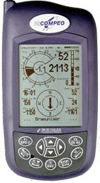 In the middle of all this time that passed, the electronics market for free flight saw a union of two giants: Flytec and Brauniger integrated around 2004 (I don't remember for sure). In fact, Brauniger left the market and Flytec (in a kind of joint venture - but that was not what actually happened) took over the production of the two products. Internally the Flytec and Brauniger products became the same (hardware and firmware) but the external brands and designs continued to be individualized (agreement between the parties). As soon as the agreement passed, the Brauniger brand left the market and only the Flytec brand followed.
 In this time of common production, the first products launched with different packaging but exactly the same content were a second generation of Galileo, but now produced by Flytec and packaged with the two brands: Brauniger IQ Compeo and Flytec 5030 GPS.
Despite the efforts of some other manufacturers, including Aircotec with its "State of the Art" Top Navigator (so good and so complete that it has not undergone any changes throughout its life - unfortunately it got way ahead of its time) ... so, despite the efforts of others, Flytec / Brauniger took the clear lead in the market and established itself as the best option for more serious XC flights and as the absolute standard in Hang Gliding and Paragliding Competitions.
Well-known brands, large and simple screens, individualized buttons for functions (maximum 2 functions per button), objectivity of the instrument menu and practicality for configuring XC or Competition routes were differentials that launched IQ Compeo and 5030 to the "top of mind" and "wish list" of pilots all over the world.
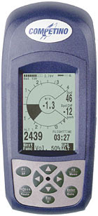 With a robust and complete product on the market, Flytec / Brauniger looked a little further and realized that there was an audience to serve with a more compact and, mainly, cheaper product. The IQ Competino and the 5020 were launched on the market. At that time I renewed my partnership with Flytec and did the translation of the official manuals in Portuguese of the integrated ones and also of the various basics of the new 5000 family (all manuals were perfectly suited for the whole family of Brauniger products). * From that moment on, where I use 5030 or 5020, it goes for Compeo and Competino too * I confess that, despite having everything I needed in the 5030, I loved the compact and more objective format of the 5020. I even think the 5020 it served better and more objectively the vast majority of pilots who used the 5030 without consuming much of what was there at their disposal. The pilots did not practice Speed to Fly (upper bar on the right side of the 5030), did not use the McCready ring to accelerate more or less in the strips (narrow circle outside the circle of the various analog of the 5030) ... they had everything, but they did not use . And both the 5030 and 5020 had navigation support for automated XC and Competition routes.
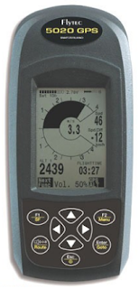
The 5020 final shot screen, which was not available in the 5030, was something very cool and totally innovative. It was taking to the goal, sitting the foot and visually controlling the little paraglider in the vertical line and above the horizontal. I even saw very clearly that the 5020 was the ideal equipment for Race events, where one looks a lot at the other drivers to mark position and evaluate performance and less for the electronic. But, you will understand people's minds. The 5030, in my view, was the overall, the XC equipment with all the information. On XC flights you fly more moments alone, you don't have as many visual references from other pilots, and you can evaluate performance data alone and adjust posture with your instrument.
 After some time, always researching the world market and monitoring the technologies available for our sport, I was curious about the Aircotec XC-Trainer dual. The device arrived with all the technology embedded in TopNavigator (his older and more experienced brother), but with a more conventional design to try to please more pilots on the market. The product, evaluating the embedded program, was simply very promising. The analysis data was very good, the operation very reliable and brought a simply different feature for a more dedicated pilot: dual barometric sensor. This "double sensor" meant that one of the barometric sensors had a scale with its amplitude divided into smaller segments to generate greater sensitivity. This sensor would not support high altitudes, but it would have a sensitivity doubled at low altitudes, that is, the pilot would have a much more sensitive sensor exactly at the moment when a more sensitive one makes a difference, when it is low. There are some features that I think are simply absurd, good and necessary: objective and sensitive thermal tracking, external temperature sensor and a graphical view of the thermal intensity by altitude range. The XC-trainer has a completely modular assembly concept, allowing you to change any part of the unit simply and independently at home and without using special tools. Well, the variety had a lot of potential, but it came to the market with many practical limitations that took time to be admitted and improved: Limit of the size of the radius of a pestle (I had a problem to mark a pestle in a race here in Brazil), Visual navigation fought in North-Up and ultra super mega complexity to use with the 3 buttons. Perfect buttons to operate with thick gloves, but I needed to be a phd to learn how to use and know which, which, when and how to tighten them. It took Bruce Goldsmith more than an hour to shut down what he used for a review for XCMag. Over time, better, better, better versions came out ... but I stopped using them. And the buttons ... remain with the same complexity.
 Following the natural path and attentive to what the market pointed out as a novelty or possibility, I came across the option of using programs on PDA devices and also on PNAs to fully support navigation together, even without connection, with a common variometer. At that time, I immersed myself in the C-Pilot program that ran on PDA devices, like the Palm, and on the LK8000 that ran on PNAs, like vehicular GPSs. What I can say is that the C-Pilot program was a show, practical and totally adherent to what it was dedicated to: free flight competitions. The LK8000 was born out of a separation from within the XCSoar, which for a long time stood still in time and focused on specific glider practitioners. This separation allowed the LK8000 to fully orient itself in free flight, mainly paragliding, and to accelerate the development of highly specialized resources for XC flight and also for Competitions. To this day, I am amazed by the LK8000. I see it as a program that delivered "almost" everything and still a little more than we need for the performance flight, whether in XC or in Competition. Maaaasssss, as nothing in the world can be perfect, there was no hardware platform on the market that would run the LK8000 with a minimum of practical visibility for outdoor use, with incidence of sunlight, on board a paraglider. I tested several resources and approaches, except for some less conventional ones, which did not seem aesthetically pleasing or practical on a daily basis. At that time I met the people at Tirante A, who manufactured several basic products and a partnership was born there, as well as a project so that we could create a product that would serve the market, giving the full LK8000 a suitable platform.
 In the meantime, I started using the Flymaster B1 Nav, and I embarked on the Tirante A world using the various special basic TAV 1100 (competition basic) that Tirante A had created for me. Unfortunately, the market didn't take much notice of the TAV 1100 ... normal, it didn't take notice of so much good that appeared. The TAV 1100 had unique and exclusive features not found in any other basics of planet Earth. In the TAV 1100 the pilot was able to set altitude limits for alerts, he could configure the times of a competition test (window, start and deadline), every 20 minutes you had a view of the average of the thermals of the day and, at the end of each detected climb in thermal the various one showed you the total altitude that you gained in that thermal. Honestly, sad ... sad ... a Brazilian company that tried and tried well.
 As long as the planned product of Tirante A does not come out, I went using the B1 Nav. The product was promising but still very square at first. The SOL team had some problems in the beginning and the communication for requesting resolutions was not very effective. I had my problems in relation to the product and ended up having a tantrum ... unfortunately, they were dealing with a user who had already used everything and still with a mental background of a computer programmer. Obviously, it was not easy to explain. Well, it was a phase and it passed. It passed to me and passed to them too. The latest versions of their products look very cool to me and the market has embraced them all over the world. Flymaster was very happy to bet on the real-time tracking (gsm) feature and gave a show of market strategy as a company partnering with events of weight and reference in our sport. The current SD versions bring features that make the difference: freedom of design of the screens, automatic upload of the flight at the end of the flight, topographic map and the dear thermal mapping ball. In my view, it is the equipment that has quickly taken its place in the market and has been maintained with a quality product and in constant innovation. It is a hat-trick and it is a reference for business strategy for other manufacturers.
  The wait for the Tirante A product continued and I was flying and participating in the project remotely with the specifications and other suggestions. I used my various advanced, the B1 nav, a Garmin 76Map and also the C-Pilot program to carry out analysis and ideas for what we could implement in the Tirante A. product. The possibilities ranged from making a completely proprietary hardware and software platform even make only one hardware platform to run third-party programs. I even said in Castelo-ES that we were going to be the Steve Jobs of the free flight. It had everything to work.
  In the first step of our project, Tirante A released a version of the various basic, the TAV 1000 LK, which connected to a Holux GPS to feed the GPS with barometer data for the full use of the LK8000 on the Holux GPS. We had found a device that had a good sized screen, robust and with an acceptable readability for outdoor use on board a paraglider. We matured the experience and the final product was being created in the laboratory of Tirante A.
And he was born! The final product, the result of a conceptual, technical and technological partnership, was ready. Tirante A delivered the CONQUEST to the market, a full integrated for free flight and which, in addition to being robust, practical and with an absurd battery autonomy (+ 20h), could be used with the pilot's preference program. A really new device had just been created, original in design and design and that came to meet a demand for a platform visible in the open, stable, safe and with long battery life for use in free flight. I feel very happy to have contributed to this project. On the other hand, despite knowing that this was expected, I was frightened by how much, here within Brazil, there were sabotage movements and actions against the Conquest product. Ai ai ai ... the human being. There were several fronts of attack and the creation of false information that gradually made life difficult for Conquest and LK8000, which also affected Conquest. Well, none of this would have had strength if the pilots were more enlightened but, as the vast majority just take the paraglider, go to the ramp, open and take off, many false and unfounded information were undermining the product. Well, other than that, the LK8000 itself faced a moment of rupture when it had to take an action and ended up not taking it. The use of the LK8000 was exploding all over the world, many people were believing and using the program and, with this increase, it is obvious that many less prepared users started to interface with it. At this peak, it was latent that the LK8000 had a major weakness: the very long learning curve. The program, which I think is fantastic, seemed like an indomitable monster to many pilots. I had contact with a French collaborator, Bruno, who worked with the interface design of the LK8000 and I passed him prototypes of the LK8000 entry interface that would simplify the lives of more than 80% of the pilot users. He tied himself up, agreed and believed ... but the thing was not carried forward inside. Well, it happened. The LK8000 has been thrown into limbo for products that are good but too complicated to use. Remember that Conquest and LK8000 participated in the penultimate world record for free distance set by the SOL team.
Well, in 2013 I got tired of everything in the world of free flight and ended up collecting a little bit of everything I lived on paragliding. I ended all my partnerships in the sport and reserved myself for a more internalized moment to rethink the whole thing. All the lust was over ... everything in the sport had lost its meaning.
But then HIKE AND FLY came to my mind as a beautiful curiosity. This curiosity was growing, my research was increasing, I was reading and learning and all of this aroused a great inner joy again. He had found a new and beautiful reason to fly.
 In this return, I closed some partnerships and went back to work with Flytec again. Flytec launched a completely new equipment, with all the features and modern communication interfaces expected in a flight electronics, Connect 1. It had a very cool proposal, the roadmap for developing the resources to be made available was relatively short and the resources comprehensive . In the middle of this journey, Flytec was sold to Naviter and the new company kept only Connect 1 in its possession. This new company was renamed Volirium and the various company was renamed Smart Vario P1. Unfortunately the project has not moved and what was supposed to be a beautiful integrated of the current generation is still a cute little one with an integrated gps and wifi access. Today it basically has the features of a variety and has features for navigation of XC routes and Automated Competition. It may become a beautiful product, but today, it makes no sense.
 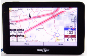 Soon after that attempt, I arrived at the Naviter integrated, the world-famous and used Oudie. Honestly, I don't see any relevant differences between him and a Conquest running LK8000. In fact the LK8000 is more complete and the Conquest more robust and versatile. Forgive me those who will read and disagree ... unfortunately I know what I'm talking about. But the focus here is not debate, it is the history and evolution of the integrated for free flight.
 The Naviter program approach is the same as the LK8000 and XCSoar program (which after years stopped in time has been resurrected and has also evolved considerably for use in paragliding). I confess that I really liked using Oudie, because the approach is the approach that I like, a very comprehensive program running on a stable hardware platform. I would say that, for those who really like to fly XC around Brazil and around the world, the best options on the market are those that have detailed maps, air space and good viewing in the sunlight. There is a piece of equipment that in terms of flying XC and pioneering routes goes very well for the most engaged pilots.
 I quickly lost interest in Oudie and as soon as I painted an opportunity I bought a Compeo again, this time the latest version - Compeo +, already with much more compact hardware and maintaining the same reliability and stability as always. No big news, except the optional ones you could ask to include in the hardware and the release of some special features by purchasing them. Once paid, you received the password and released the resource for final use. But nothing critical for daily flight. The great and incomparable differential of Compeo + for me, and for most XC and Competition drivers around the world, is its reliability. We call it a battle tank. Don't fail, don't let you down. Unlike some equipment out there (which we do not disclose) it does not give any headache to the scorers of competition results. The ability to export and import data from the SD card is very practical and reliable as well. I think this guy made a very solid contribution to world free flight. He deserved to go on with his life, win monochrome maps, win wifi communication interfaces, gprs ... but he made his contribution. I still use it!
 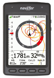 Following life and time, I still had the expectation of finding some equipment on the market that would serve me more adequately and fully in the practice of HIKE AND FLY. I use a Flytec mini variant, Sonic, in my lightweight helmet and I also wear my Suunto Ambit watch for navigation and recording of routes on the ground and in flight. But then Naviter launched Hyper, a device with an intelligent, compact, light design and with the Naviter pedigree. I couldn't resist and I bought one. It seemed to me a very suitable solution and within what I was looking for for my adventure days. Well, Naviter's proposal was to deliver to the market a device for tracking HIKE AND FLY activity as a whole, on the ground and in flight. But some initial weaknesses were complicating the relationship and trust. If you used the navigation screen with the map loaded, the screen was locked in North-UP (already resolved), the battery started not to last more than 2 hours (equipment was changed), bug in route navigation etc. Result, I am using Hyper, but I do not trust to fly only with it. After some version updates, I have not had any operation or battery problems.
  Well, we finally got to the present day and I think I couldn't be in today with some equipment so much more suitable for this today than what I have. I returned after so many years using the Digifly brand and the product I'm using is the super modern AIR BT. This product exists in two versions, this AIR BT and one exactly the same, but with a sensor and pitot tube available, the AIR BT PITOT. It is an integrated that, as it should be, brings all the information expected from an integrated flight equipment. But, from the beginning, AIR brings some very interesting technical and conceptual differences, among them, 10 sensors (very high precision and sensitivity), 5D navigation (3D + 2D), acceleration measurement (Gs), pitch and capacity measurements to function as a Flybox BLE (telemetry). One thing that is very enchanting to me in this beginning of my relationship with Digifly is the speed and ease of speaking with the Digifly team (contact centered at Digifly USA). I haven't been able to test all the features of the AIR BT yet (my unit does not have a pitot sensor - for now), but I can see that I have never used any integrated as sensitive as this (the Aircotec XC-trainer Dual is the closest). I was able to navigate an XC route, leaving the start on the Araxá ramp, hitting the pylon in the city of Araxá and closing the goal on the Araxá ramp. The automatic zooms work well, according to the settings, the glide calculations match very well (compared to Compeo + using pitot). The thermal tracker has absurd practical and intuitive functionality. The big difference is that you can see its efficiency in each thermal curve in 3D and not in 2D, as in other equipment. In this regard, the XC-trainer Dual also allows you to combine 2D vision with the barograph and better interpret the current thermal. But you can't compare with the practicality of just looking at the screen and seeing the width of the rotation lines and the drift in 3D. AIR BT has 13 screens for you to use and some of them are connected to others for automatic actions. The cool thing is that you can disable the screens you don't want to see and leave only those that interest you. In my case, for example, I am using only the XC screens and with automatic integration active. Digifly allows you to configure all the equipment's options directly on it or using a program called AirTools, which makes everything easier when you have a computer close by. And Digifly also offers a program called AirPages in which you design each screen as you wish and upload it to the equipment. In other words, observe the path we passed and see how cool our sport has evolved. Integrated products are a fundamental part of this evolution and I believe that we still have a lot to explore.
 I'm not going to talk about AIR BT much now. After testing more I will make specific material about it to help the class to know more about this super modern option on the market.
This article has been translated for your convenience and was originally written in Portuguese.

Choose from the following Sign In options to get started
Sign In with Google
Sign in with Facebook